You are here
Northwestern California Maps
 | This research guide lists both print and Internet maps that cover northwestern California. The table of contents below lists maps by theme and environment. "Other Sources" lists guides to gis and imagery resources of northwestern California as well as more general guides to California resources that may cover northwestern California. |
Gazetteers
- Durham's Place-Names of California's North Coast: Includes Del Norte, Humboldt, Lake, Mendocino and Trinity Counties (Durham) 2000 (F 867.5 D87 2000 - Humboldt County Collection)
- Klamath Places Database (Cal Poly Humboldt - Advanced Spatial Analysis Facility) Includes all of the official USGS place names for the Klamath Basin in addition to many more local place names, gauging stations and others. The database is searchable by county, watershed, category and name. Each place name is linked to a location map.
- Place Names of Humboldt County, California: A Compendium, 1542-1992 (Turner) 1993 (F 868 H8 T87 1993 - Reference and Humboldt County Collection) The major compilation of Humboldt County place names containing references to futher sources of information on specific place names.
- Trinity County Historic Sites (Trinity County Historical Society) 1981 (F 868 T6 T76 Humboldt County Collection and bookstacks) Includes historical notes on approximately 500 historical sites and place names in Trinity County. Grouped into seven geographical areas.
- Whipple Well: A Database for Mining, Prospecting, Metal Detecting, And Treasure Hunting in California: Humboldt County, Del Norte County, Siskiyou County, Trinity County, and Mendocino County (CalSign) Database of current and historical places names derived from various sources, organized by county. For each entry gives information on type of feature, geographic coordinates and U.S.G.S 7.5 minute topographic quadrangle.
General
- Arcata Maps/GIS (City of Arcata) Site includes maps available for viewing in either .jpeg or .pdf format, online mapping applications and downloadable gis data.
- Atlas of Human Adaption to Environmental Change, Challenge, and Opportunity: Northern California, Western Oregon, and Western Washington (Christensen, McGinnis, Raettig, & Donoghue) 2000 (USFS General Technical Report PNW-GTR-478) (print copy available in Docs A 13.88:PNW-478) Uses choropleth maps to show changes in the timber industry and in social, economic, and demographic characteristics that have occurred since implementation of the Northwest Forest Plan in 1989.
- Eureka Geographic Information System (City of Eureka) Site includes maps available for viewing in .pdf format, online mapping applications and downloadable gis data.
- Humboldt County, California Atlas (Plank) 1974 (G 1528 H8 H85 1974 - Atlas Collection and Humboldt County Collection) Contains 75 maps and charts covering Humboldt County arranged into five major divisions: General Reference, Physical Systems, Economic Systems, Socio-Cultural Systems, and Special Subjects.
- Humboldt County Web GIS (Humboldt County Community Development Services Department) Series of five online mapping applications covering all Humboldt County. Major datasets that can be can viewed individually or in layers include parcels, zoning, land use, flood zones, fire hazard, seismic safety, roads, streams, USGS topo quads, and aerial photography.
- Maps, Spatial Data, and Photos: Humboldt County, Del Norte County, Siskiyou County, Trinity County, and Mendocino County (Land Use Planning Information Network) Contains links to geospatial resouces on the Internet.
- North Coast (California Division of Tourism)
- North Coast/ Klamath Basin (Trust for Public Lands) Map found in State of California Rivers report.
- Russian River Integrated Information System (Russian River Watershed Council) Interactive mapper that includes data layers covering base information, watersheds, water quality, fisheries, soils, land use, vegetation, and aerial photography.
- TIGER Mapping Service: Humboldt County, Del Norte County, Siskiyou County, Trinity County, and Mendocino County (U.S. Census Bureau) Interactive mapper allows one to display one or more boundary and street data layers derived from the 1998 TIGER/Line files and 1990 Decennial Census.
Agriculture & Forestry
- Generalized Types and Age Classes of Timber Stands: Del Norte County, California (US Forest Service) 1953
- Generalized Types and Age Classes of Timber Stands: Humboldt County, California (US Forest Service) 1952
- Generalized Types and Age Classes of Timber Stands: Mendocino County, California (US Forest Service) 1951
- Generalized Types and Age Classes of Timber Stands: Trinity County, California (US Forest Service) 1951
- Generalized Types and Age Classes of Timber Stands: Coast Range Pine Subregion, California (US Forest Service) 1952
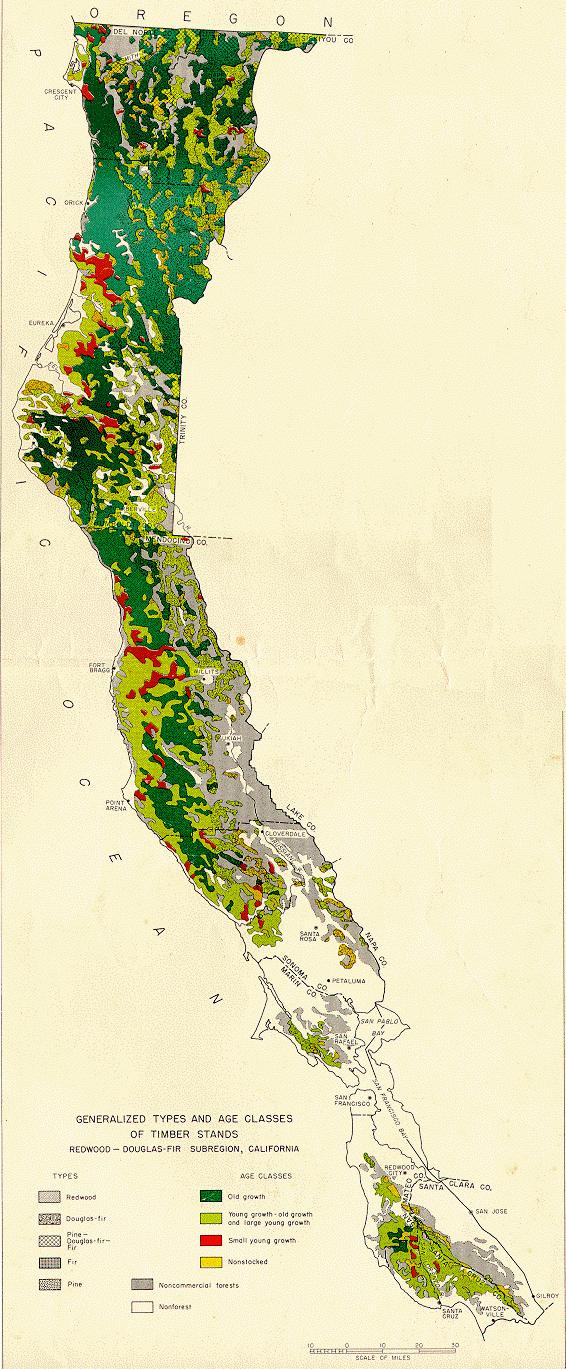
- Generalized Types and Age Classes of Timber Stands: Redwood-Douglas Fir Subregion, California (US Forest Service) 1978
- Major Ownership and Land Classes: Coast Range Pine Subregion, California (US Forest Service) 1948
- Major Ownership and Land Classes: Redwood -- Douglas-Fir Subregion, California (US Forest Service) 1949
- Property Maps (Mendocino Redwood Company) Series of maps show major owners of forest land in Mendocino County from 1955 to 2005 in five year increments.
- Timber and Other Vegetation Types, Siskyou County, California (US Forest Service) 1950
- Timber and Vegetation Classes, Northern Mendocino County, California 1945 (US Forest Service) 1945
- Timbered Area, State of California, Northern California (Berkeley Digital Library) California State Conservation Commission map of 1912 shows ownership of private timber lands by timber company.
- Timber-Stand--Vegetation Cover Maps (California Cooperative Soil Vegetation Survey) (map G 4361 K2 s31 U5) Series of 467 maps produced between 1948 and 1962 at a scale of 1:31,680 which map timber stand characteristics in northern California.
Coast & Ocean
- Regional Profile of the North Coast Study Region (California-Oregon Border to Alder Creek) (California Marine Life Protection Act Initiative) 2010 (print copy available in Cal Docs R960 M36 2010) Prepared for the Marine Life Protection Initiative, the profile and accompanying atlas provide information on the habitats, species, land-sea interactions and socioeconomic setting of California's coast from the California-Oregon border to Alder Creek near Point Arena in Mendocino County. The companion thematic atlas contains large-format maps in two parts -- the Coastal Management & Human Uses Atlas and the Habitat & Species Atlas. Spatial data layers are available at MarineMap.
Demography
- American FactFinder (US Census Bureau) Includes data from the Decennial population census, the annual American Community Survey, the Economic Census conducted every five years and annual economic surveys. Interactive ":reference maps" show selected geographic boundaries and features. "Thematic maps" show geographic patterns in statistical data, such as population or median income, displayed as color-coded areas on a map.
- Census Tract/Block Numbering Area Outline Map (1990) [County] In 1990 Census of Population and Housing: Population and Housing Characteristics for Census Tracts and Block Numbering Areas: California (Outside Metropolitan Areas: Maps (US Census Bureau) (Docs C 3.223/11: 1990 CPH-3-6 Maps) Includes separate census tract maps for Humboldt, Del Norte, Siskiyou, Trinity and Mendocino Counties.
- Census Tract Outline Maps: Humboldt, Del Norte, Siskiyou, Trinity, Mendocino (US Census Bureau) (Print copy available in Docs C3.275 M32 DVD--cd-rom cabinet) PDF maps of 2000 Census tracts. The first map in each county is an index to the tract maps. Similar maps can also be generated using American Factfinder's "reference maps."
- County Block Maps: Humboldt, Del Norte, Siskiyou, Trinity, Mendocino (US Census Bureau) PDF maps of 2000 Census county block maps. The first map in each county is an index to the block maps. Similar maps can also be generated using American Factfinder's Reference Maps.
- 1980 Census Tracts: Humboldt County Calif. In Census Tracts: California: Selected Areas (US Census Bureau) (Docs C 3.223/11: 1980/6 Maps)
Ecology
- California Coastal Salmon Region Geographic Information (Information Center for the Environment. California Rivers Assessment) Includes a series of maps that show land use and species richness in northwestern California.
- National Wetlands Inventory (US Fish & Wildlife Service) (microfiche copies in Docs I 49.6/7-12; print copies for Humboldt and Del Norte County available in the Humboldt Room Map Case) Series of maps at scales of 1:24,000 and 1:100,000 for the United States which classify wetlands into 55 different classes using the Classification of Wetlands and Deepwater Habitats of the United States (Cowardin) 1979 (print copy available in Docs I e49.89:79/31). National Wetlands Inventory Maps lists maps available for each state, including California. For additional information see Wetland Mapping and Inventory (US Geological Survey). Wetlands Mapper (US Fish & Wildlife Service) is an interactive mapper that allows one to view National Wetlands Inventory digital data as well as stream and road data. You can also view wetlands data layers with Google Earth.
- North Coast Integrated Regional Water Management Plan Areas of Biological Significance (North Coast Integrated Regional Water Management Plan) Maps Marine Water Quality Protection Areas in Del Norte, Trinity, Humboldt, Mendocino and Sonoma Counties.
- Southern Oregon-Northern California Bioregional Domain Wildlife Habitat Map & Database (Cal Poly Humboldt. Spatial Information Systems Institute)
- Wetlands and Deepwater Habitats of the Humboldt Bay and Eel River Delta (US Fish & Wildlife Service) 1987 (print copy available in the Humboldt County Collection Map Case) 1:62,500 scale map recompiled from more detailed National Wetlands Inventory maps that depict six basic wetland types.
Energy & Mineral Resources
Environmental Pollution
- Central and Northern California Coastal Marine Habitats: Oil Residence and Biological Sensitivity Indices: Final Report (Woodward-Clyde Consultants) 1982 (POCS Technical Paper #83-5) (Docs I 53.29/2:83-5; maps shelved in Documents Map Case) Prepared for the US Minerals Management Service Pacific Outer Continental Shelf Region. Includes a narrative report that describes the geological and biological characteristics of the California coast from Point Conception to the Oregon border; the development of biological sensitivity and oil residence indices that identify areas of potential concern in the event of an oil spill; and counter measures available to protect or cleanup areas of high concern. The accompanying map set includes a set of 130 1:24,000 scale maps and accompanying legends that characterize in detail physical and biological shoreline features and show biological sensitivity and oil residence indices; and a set of eight 1:250,000 scale maps that provide a more general physical characterization of shoreline features and repeat the biological sensitivity and oil residence indices.
- Northern California Environmental Sensitivity Atlas (California Department of Fish and Game. Office of Spill Prevention and Response) Uses USGS 7.5 minute quadrangles as a base map to present three types of information that can be used in oil spill contingency planning and assessment--shoreline classification as it relates to oil contamination sensitivity, sensitive human-use resources such as water intakes, and sensitive biological resources such as seabird colonies. Produced by the US National Ocean Service Office of Response and Restoration, Environmental Sensitivity Index Maps are also available as pdf images through the NOS Data Explorer interactive mapper. For further information see ESI Maps.
- GeoTracker: Humboldt County, Del Norte County, Siskiyou County, Trinity County, and Mendocino County (California State Water Resources Control Board) Interactive mapper that emphasizes data layers for Leaking Underground Fuel Tanks (LUFTs) and public drinking water wells. Other available data layers include Underground Storage Tanks (USTs), roads, topography and watersheds.
Geology
Listed are maps that for the most part are at a scale of 1:100,000 or smaller. For site specific studies see the indexes to geologic mapping typically included with these maps and the Indexes and Guides to California geologic mapping.
- Correlation of the Klamath Mountains and the Sierra Nevada (Irwin) 2002) (print copy available in map G 4362 K4 C57 2003) (USGS Open-file Report 02-490) Two sheets portray the broadly parallel tectonic development of the Klamath Mountains and the Sierra Nevada from early Paleozoic to Early Cretaceous.
- Geologic-Landslide Maps (California Department of Forestry) 1979 (map G 4361 C5 s62 C2) Series of maps published on a USGS 15' quadrangle base at a scale of 1:62,500 that map the geology and land form stability of coastal northern California. Originally prepared for use in timber harvest plan preparation they have been superceded in part by the more recent Geology and Geomorphic Features Related to Landsliding series. The Index to Published Landslide Maps, California Coast Ranges, Monterey County and North for Use in Timber Harvest Plan Preparation on Non-Federal Land (Print copy available in Cal Docs C 810 S59 #120) can be used as a guide to the series.
- Geologic Map of California: Redding Sheet (Strand) 1962 (print copy available in Cal Docs C810 G4 R35) Includes 1:250,000 scale geologic map that shows the regional distribution and interrelationships of rock units and major geologic structures present. Accompanying each sheet is an Index to Geologic Mapping used in compilation of the sheet, a Stratigraphic Nomenclature chart, and a list of Topographic Quadrangles used as a base for the sheet. The geologic map also has been collectively published in the Geologic Atlas of California (Atlas G 1526 C5 C25 1968 folio).
- Geologic Map of California: Weed Sheet (Strand) 1963 (print copy available in Cal Docs C810 G4 W4) Includes 1:250,000 scale geologic map that shows the regional distribution and interrelationships of rock units and major geologic structures present. Accompanying each sheet is an Index to Geologic Mapping used in compilation of the sheet, a Stratigraphic Nomenclature chart, and a list of Topographic Quadrangles used as a base for the sheet. The geologic map also has been collectively published in the Geologic Atlas of California (Atlas G 1526 C5 C25 1968 folio).
- Geologic Map of the Klamath Mountains (Irwin) 1994 (USGS Miscellaneous Investigations Series I-2148) (G 4362 K4 1994 I78 Hum Co Coll) Geologic map at a scale of 1:500,000. Cumulation of many years of work by William P. Irwin in the Klamath Mountains. Includes Index to Sources of Map Data.
- Geologic Map of the Red Bluff 30'x60' Quadrangle, California (Blake) 2000 (USGS Geologic Investigations Series I-2542) (print copy available in Docs I 19.91:I-2542) Geologic map at a scale of 1:100,000.
- Geologic Map of the Redding 1x2 Degree Quadrangle, Shasta, Tehama, Humboldt, and Trinity Counties, California (Fraticelli, et al) 1987 (USGS Open File Report 87-257) (print copy available in Docs I 19.76:87-257) Geologic map at a scale of 1:250,000.
- Geology of the Cape Mendocino, Eureka, Garberville, and Southwestern Part of the Hayfork 30x60 Minute Quadrangles and Adjacent Offshore Area, Northern California (McLaughlin, et al.) 2000 (USGS Miscellaneous Field Studies MF 2336)( print copy available in the Humboldt Room Map Case) Geologic map at a scale of 1:100,000. Maps and report available in postscript, pdf, and Arc/Info export formats.
- Geology and Geomorphic Features Related to Landsliding (California Division of Mines and Geology and California Department of Forestry and Fire Protection) Using USGS 1:24,000 quadrangles as a base this series provides detailed mapping of the geology and geomorphic features affecting landslide potential, soil erosion, and streambank erosion in sensitive watersheds mainly in Mendocino, Humboldt, and Del Norte Counties of California.
- North Coast Watersheds Mapping (Cal Docs C 810 O63 various numbers and Humboldt County Collection map files; cd-rom version containing both pdf and GIS files is available in Cal Docs C810 W39) Set of 60 quadrangles produced between 1982-1985. CGS/CDF Watersheds Mapping includes a description and index to these maps The pdf versions contain two layers--"Geologic Features Map" and "Geomorphic Features Map".
- Forest and Watershed Geology Program - Maps and GIS Data Includes additional geological, landslide and landslide potential mapping organized by watershed and which is available on cd-rom or by download. Includes both pdf and gis files.
- Noyo River (cd-rom available in CalDocs C810 N69cd)
- Freshwater Creek (cd-rom available in G 4363 H8 F35 2002 Hum Co Coll)
- Elk River (cd-rom available in GB 991 C2 M37 2005 Hum Co Coll)
- Gualala River
- Redwood Creek
- Mattole River
- Albion River
- Big River
- Geology and Ground Shaking: Northern California (Moley & Dengler) 1992 (Map File-Humboldt Room) Four-color map at a scale of 1:250,000 that shows faults and general subsurface geology and their relationship to localized ground shaking.
- Geology of the Northern California Continental Margin (Clarke & Field) 1989 (Cal Docs C 810 C66 #7) Part of the California Continental Margin Geologic Map Series published by the California Division of Mines and Geology. Includes four maps at a scale of 1:250,000: Geologic Map; Bouquer Gravely and Magnetic Anomaly; Earthquake Epicenters and Selected Fault Plane Solutions; and Well Location, Geophysical Trackline and Data Source Map. Geology of the California Continental Margin (CDMG Bulletin 207) (Cal Doc C 810 B9 #207) contains an explanation of the entire map series along with a 37-page bibliography.
- Map Showing Geologic Structures of the Northern California Continental Margin (Clarke) 1990 (G 4363 H8 C55 1990 C53 Hum Co Coll) (USGS Miscellaneous Field Studies Map MF-2130) 1:250,000 scale map that shows offshore faults and folds from Point Delgada to the Oregon border.
- Reconnaissance Geologic Map of the Covelo 30- by 60-minutes Quadrangle, Northern California (Jayko, Blake, McLaughlin, Ohlin, Ellen, & Kelsey) 1989 (USGS Miscellaneous Field Studies Map MF-2001) (Docs I 19.113:MF-2001) Geologic map at a scale of 1:100,000.
- Regional Geologic Map Series: Weed Quadrangle (California Division of Mines and Geology) 1987 (Cal Docs C 810 R43 #4A) Geologic map at a scale of 1:250,000. Includes 4 sheets: Geologic Map, Geologic Map Explanation, Index to Geologic Map Used in Compilation, and Location Map of Rock Samples Dated by Radiometric. Replaces the older Weed Quadrangle in the Geologic Map of California series.
Historical
- Arcata Historic Resource Sensitivity Map (Streamline Planning Consultants) Map shows Arcata historic districts and post World War II subdivisions.
- Atlas of Humboldt County, California Compiled from Official Records and Private Sources and Surveys (Belcher Abstract & Title Co) 1921-22. Shows drainage, settlements, roads, trails, railroads, township and section lines, parcel ownership, and Indian allotments. Atlas of the World: Humboldt County, Del Norte County, Siskiyou County, Trinity County, and Mendocino County (Rand McNally) 1895
- Baie De La Trinidad (Duflot de Mofras) 1844. Map of Trinidad Harbor published in Exploration Du Territoire De L'Oregon, Des Californies Et De La Mer Vermeille, Executee Pendant Les Annees 1840, 1841 Et 1842.
- Eureka, Humboldt County, California (Library of Congress) Image of 1902 Noe and Georgeson panoramic map of Eureka. (Print copies also available in the Humboldt Room Map Case.)
- Eureka Survey, 1884 (Thygeson) Survey conducted in 1884 for the Belcher Abstract & Title Co. Six sheet "Sanborn"-type map shows outlines of buildings, along with ownership in some cases. Includes many of the major lumber mills.
- Historical Map and Chart Collection (US NOAA. Office of Coast Survey) Contains over 20,000 maps and charts from the late 1700s to present day. The Collection includes some of the earliest US nautical charts, hydrographic surveys, topographic surveys, bathymetric maps, geodetic surveys, city plans and Civil War battle maps. Search by keyword, geographic area, type of map, date, or chart number.
- Metsker's Atlas of Del Norte County, California (Metsker Maps) 1949 (G 1528 D4 M47 1949 Humboldt County Collection) Series of township-based maps that show land ownership as well as basic physical and cultural features.
- Metsker's Atlas of Humboldt County, California (Metsker Maps) 1950 (G 1528 H8 G46 M47 1950 Humboldt County Collection) Series of township-based maps that show land ownership as well as basic physical and cultural features.
- Northern California (Holdredge) 1866. Map stretches from California's northern border to San Francisco Bay. Contained within the David Rumsey Collection.
- Nouvelle Californie IN Atlas universel de géographie physique, politique, statistique et minéralogique sur l'échelle de 1/1641836 ou d'une ligne par 1900 toises / (Vandermaelen) 1827. Maps shows northern California. Contained within the David Rumsey Collection.
- Place Names of Humboldt County, California: A Compendium, 1542-1992 (Turner) 1993 (F 868 H8 T87 1993 - Reference and Humboldt County Collection) The appendices include maps covering the formation of Humboldt County; California historical landmarks in Humboldt County; historical sites/spots in Humboldt County; Humboldt County ferries/crossings and fords; Humboldt County trails and wagon roads; harbors/ports/landings/wharfs; and railroads of Humboldt County.
- Sanborn Fire Insurance Maps - Starting in 1867 the Sanborn Map Company began the production of fire insurance maps that eventually covered 12,000 communities in the United States, Canada, and Mexico. These large scale maps, drawn at scales of 1"=50' and 1"=100', were created to assist fire insurance agents in determining the degree of risk associated with commercial, industrial, and residential property within a community. Shown on the maps are the "footprints" of individual buildings, including their dimensions, shape, height, location of doors and windows, building material, and uses; and other property details and city improvements, including lot lines, street widths, fire hydrants, and other fire-fighting facilities. A key to map notations provided by the Sanborn Map Company is available.
- Sanborn Fire Insurance Maps (UC Berkeley Map Library) This is the introduction found in Fire Insurance Maps in the Library of Congress: A Checklist (Library of Congress. Geography and Map Division) 1981 (Docs LC 5.2:F51) that lists fire insurance maps found in the Library of Congress.
- Fire Insurance Maps: Their History and Applications (Oswald) 1997 (HG 9771 O89 1997)
- Today these maps frequently represent the most detailed information on historical urban land use and are used by scholars and professionals in history, geography, architecture, and environmental engineering. For additional background information on fire insurance maps see:
- Insurance Maps, Eureka, California (Sanborn Map Company) 1920 with updates through 1949 (G 1529 E9 S3 1920 Hum Co Coll) An atlas volume with individual sheets covering Eureka on a block-by-block basis.
- California Maps: North-Coast Towns, 1886-1946 (Shkurkin) 1986 (microfilm MF 2503 and selected print reproductions in Humboldt Room Map Case) Contains fire insurance maps for 23 towns in Humboldt and Mendocino Counties. See Index to California Maps: North-Coast Towns, 1886-1946 for a list of available towns and dates of coverage.
- The Cal Poly Humboldt Library has the following collections of Sanborn fire insurance maps covering northwestern California:
- University of California, Berkeley Earth Sciences and Map Library
- University of California, Davis Government Information and Maps Department
- California State University, Northridge Geography Map Library
- Special Collections Maps (California State Univeristy, Chico Merian Library Special Collections) While the emphasis is on northeastern California there are numerous maps that include northwestern California. Browse the entire collection or search by place or subject.
- Library holdings. Indexes are available at each library to their California holdings.
Land Ownership and Use
- Arcata Community Forest 3D Map (City of Arcata)
- Arcata Historic Resource Sensitivity Map (Streamline Planning Consultants) Map shows Arcata historic districts and post World War II subdivisions.
- Atlas of Humboldt County, California Compiled from Official Records and Private Sources and Surveys (Belcher Abstract & Title Co) 1921-22. Shows drainage, settlements, roads, trails, railroads, township and section lines, parcel ownership, and Indian allotments.
- Coastal Assessment and Data Synthesis System (CA&DS) Land Use and Population: Eel River Estuarine Drainage Area, Humboldt Bay Estuarine Drainage Area, Klamath River Estuarine Drainage Area (US National Ocean Service. Special Projects Office) Contains static images generated from an interactive mapper; one can also use the Make a Map interactive mapper to create custom maps for each watershed that includes data layers for eight major themes (population, estuarine living marine resources, land use/land cover, shellfish harvest, hydrology, eutrophication, and socioeconomic).
- Eureka Survey, 1884 (Thygeson) Survey conducted in 1884 for the Belcher Abstract & Title Co. Six sheet "Sanborn"-type map shows outlines of buildings, along with ownership in some cases. Includes many of the major lumber mills.
- Humboldt Bay Wetlands Review & Baylands Analysis (Shapiro & Associates) 1980 (F 868 H8 S532 1980 Hum Co Coll) Three volume report prepared for the US Army Corps of Engineers that reviews and maps the physical, biological, land use and cultural resources of Humboldt Bay and its environs. Vol. 3 and accompanying 25 sheet map set at a scale of 1:6000 (map set filed in Humbold Room map case) classify land use into 17 general classes and wetlands into 20 classes that can be equated to the National Wetlands Inventory classification system.
- Humboldt County Existing Land Use (Humboldt County Community Development Services) 2002. Also includes statistical table by land use category that shows # of parcels, acreage and % of county with that land use.
- Interactive Housing Inventory Mapping System (Humboldt County Community Development Services) Interactive map of all parcels in Humboldt County. Use the interactive map or search by parcel number, street address, or by matching criteria such as size, zoning, and housing density. An aerial photography background can be turned on. Each parcel contain information on zoning, assessment value, size in acres, constrained acres, developable acreas, and maximum number of dwelling units. Designed to receive feedback on parcels included in the County's Housing Inventory.
- Humboldt County Private Land Ownership (Humboldt County Community Services District) 2002. Maps the 18 largest private land holdings plus others with more than 640 acres. Tables shows 40 largest private land owners with statistics for # of parcels and acreage; and all land ownership in Humboldt County subdivided by private lands and public lands.
- Humboldt County Public Lands (Humboldt County Community Services District) 2002. Maps federal, state, local jurisdiction and tribal lands in Humboldt County. Statistical table shows acreage and # of parcels by agency.
- Klamath River Basin Land Use/Land Cover Map (US Natural Resources Conservation Service)
- Klamath-Siskiyou Ownership (low resolution, high resolution) (Conservation Biology Institute)
- Klamath-Siskiyou Roadless Areas by Size Class (low resolution, high resolution) (Conservation Biology Institute)
- Major Ownership and Land Classes: Coast Range Pine Subregion, California (US Forest Service) 1948
- Major Ownership and Land Classes: Redwood -- Douglas-Fir Subregion, California (US Forest Service) 1949
- National Wetlands Inventory (US Fish & Wildlife Service) (print copies for Humboldt and Del Norte County available in the Humboldt Room Map Case) Series of maps at scales of 1:24,000 and 1:100,000 for the United States which classify wetlands into 55 different classes using Classification of Wetlands and Deepwater Habitats of the United States (Cowardin) 1979 (print copy available in Docs I 49.89:79/31). For additional information see Wetland Mapping and Inventory (US Geological Survey). Wetlands Interactive Mapper Tool (US Fish & Wildlife Service) is an interactive mapper that allows one to view National Wetlands Inventory digital data as well as stream and road data. Also includes a link to the Microsoft TerraServer which allows one to view an aerial photograph or topographic map of the same area being viewed.
- North Coast/Klamath CERES Bioregion: Land Ownership (CERES) Static map generated from ICE Maps.
- North Coast/Klamath CERES Bioregion: Land Use/Land Cover (CERES) Static map generated from ICE maps.
- Property Maps (Mendocino Redwood Company) Series of maps show major owners of forest land in Mendocino County from 1955 to 2005 in five year increments.
- Six Rivers National Forest Inventoried Roadless Areas (US Forest Service) Prepared for USFS Roadless Area Conservation Final EIS.
- Timbered Area, State of California, Northern California (Berkeley Digital Library) California State Conservation Commission map of 1912 shows ownership of private timber lands by timber company.
- Wetlands and Deepwater Habitats of the Humboldt Bay and Eel River Delta (US Fish & Wildlife Service) 1987 (print copy available in the Humboldt County Collection Map Case) 1:62,500 scale map recompiled from more detailed National Wetlands Inventory maps that depict six basic wetland types.
Marine
See also Humboldt Bay and Other Estuarine Environments.
- Baie De La Trinidad (Duflot de Mofras) 1844. Map of Trinidad Harbor published in Exploration Du Territoire De L'Oregon, Des Californies Et De La Mer Vermeille, Executee Pendant Les Annees 1840, 1841 Et 1842.
- Bathymetry of the Northern California Continental Shelf (California Department of Fish and Game) Map found in California's Living Marine Resources: A Status Report.
- Central and Northern California Coastal Marine Habitats: Oil Residence and Biological Sensitivity Indices: Final Report (Woodward-Clyde Consultants) 1982 (POCS Technical Paper #83-5) (Docs I 53.29/2:83-5; maps shelved in Documents Map Case) Prepared for the US Minerals Management Service Pacific Outer Continental Shelf Region. Includes a narrative report that describes the geological and biological characteristics of the California coast from Point Conception to the Oregon border; the development of biological sensitivity and oil residence indices that identify areas of potential concern in the event of an oil spill; and counter measures available to protect or cleanup areas of high concern. The accompanying map set includes a set of 130 1:24,000 scale maps and accompanying legends that characterize in detail physical and biological shoreline features and show biological sensitivity and oil residence indices; and a set of eight 1:250,000 scale maps that provide a more general physical characterization of shoreline features and repeat the biological sensitivity and oil residence indices.
- Coastal Survey Maps (US National Ocean Service) This part of the NOS Data Explorer provides access to historical planimetric or topographic coastal survey maps (also known at T-sheets) that precisely define the shoreline and nearshore natural and manmade features, such as rocks, bulkheads, jetties, piers, and ramps. Maps range in scale from 1:5,000 to 1:40,000 and serve as the basic database of shoreline and topography used in the production of nautical charts. Historical data from these surveys is often used in litigation to determine property ownership, to enforce regulatory mandates, and to estimate rates of shoreline change. The NOS server includes tif images of 6,000 coastal suvery maps. Northwestern California suveys date between 1919 and 1950 and range in scale from 1:10,000 to 1:20,000. Within the NOS Data Explorer click on the "Topics" tab, draw a search box to specify the northwestern California geographic area and under "Choose Topics" select "Shoreline-Shoreline Surveys". On the resulting map use the the "Link to Data" tab to create a list of available surveys. (Note: if the tif image does not open, right click on the image you want to view and choose the "Save Target as..." option to save the file; then use an image editor to view the image.)
- Coastal Topographic Sheets (T-sheets): Northern California (US Coast Survey) Highly detailed topographic maps of the northern California shoreline that were created by the US Coast Survey. Maps for the northwest coast dates from 1854 to 1871. The "T-Sheets" contain historical information such as locations of buildings and detailed descriptions of shorelines.
- Northern California Environmental Sensitivity Atlas (National Ocean Survice. Office of Spill Prevention and Response) Uses USGS 7.5 minute quadrangles as a base map to present three types of information that can be used in oil spill contingency planning and assessment--shoreline classification as it relates to oil contamination sensitivity, sensitive human-use resources such as water intakes, and sensitive biological resources such as seabird colonies. Produced by the US National Ocean Service Office of Response and Restoration, Environmental Sensitivity Index Maps are also available as pdf images through the NOS Data Explorer interactive mapper. For further information see ESI Maps.
- Geology of the Northern California Continental Margin (Clarke & Field) 1989 (Cal Docs C 810 C66 #7) Part of the California Continental Margin Geologic Map Series published by the California Division of Mines and Geology. Includes four maps at a scale of 1:250,000: Geologic Map; Bouquer Gravely and Magnetic Anomaly; Earthquake Epicenters and Selected Fault Plane Solutions; and Well Location, Geophysical Trackline and Data Source Map. Geology of the California Continental Margin (CDMG Bulletin 207) (Cal Doc C 810 B9 #207) contains an explanation of the entire map series along with a 37-page bibliography.
- Nautical Charts (US Coast and Geodetic Survey and US National Ocean Service)
- Historical nautical charts of Northwestern California are available in the Humboldt Room Map Collection.
- Historical Map and Chart Collection (US NOAA. Office of Coast Survey) Contains over 20,000 maps and charts from the late 1700s to present day. The Collection includes some of the earliest US nautical charts, hydrographic surveys, topographic surveys, bathymetric maps, geodetic surveys, city plans and Civil War battle maps. Search by keyword, geographic area, type of map, date, or chart number.
- Maptech MapServer: Nautical Charts (Maptech) Displays National Ocean Service nautical charts (general, coastal, and harbor) for the coastal and Great Lakes regions of the United States. Search for charts by placename, zip code, or geographic coordinate. For a geographic area several scales may be available. One can pan to adjacent charts and display portions of each chart at 100% or 50% resolution. Print, save, or email what is being displayed.
- U.S. Coastal Maps (US National Ocean Service. Office of Coast Survey) US nautical charts that have been cleaned of all navigational aides and symbols leaving just cultural, hydrographic and topographic features. Available for online viewing as .jpeg files and for download into a GIS as a georeferenced .tiff file.
Natural Communities & Habitats
- Klamath-Siskiyou Physical Habitat Types (low resolution, high resolution (Conservation Biology Institute) See Klamath-Siskiyou Conservation Assessment for code key.
- Wildlife Habitats: Multi-Source Land Cover Data: Humboldt County, Del Norte County, Siskiyou County, Trinity County, Mendocino County (California Department of Forestry and Fire Protection) 2004. Compiled for the Forest and Range 2002 Assessment using California Wildlife Habitat Relationships System habitats.
Natural Hazards
- Annual Seismicity Maps for the Cape Mendocino Area (Berkeley Seismological Lab ) Includes annual maps from 1998 to the present that cover from Shelter Cove to the northern California border. Also includes links to maps covering the most recent week, most recent month and current year to date. For each map includes list of plotted earthquakes.
- Depth to the Juan De Fuca Slab Beneath the Cascadia Subduction Margin--A 3-D Model for sorting Earthquakes (McCrory, Blair, Oppenheimer, and Walter) 2004 (cd-rom copy available in Docs I 19.121:19) Model of the Juan de Fuca slab beneath southern British Columbia, Washington, Oregon, and northern California separates earthquakes occurring above and below the slab surface. Includes maps, gis files, files of earthquakes above and below the slab surface and a 3-D animation or fly-through showing a shaded-relief map with plate boundaries, the slab surface, and hypocenters for use as a visualization tool.
- Earthquake Fault Zone Maps (formerly Special Studies Zone Maps) (California Divison of Mines and Geology) (print maps for northwestern California are located in the Humboldt County Collection Map Case; for the rest of California see Digital Images of Official Maps of Alquist-Priolo Earthquake Fault Zones of California, a series of three cd-roms that contain Earthquake Fault Zone Maps for the entire state (Cal Docs C 810 A57)) Series of maps at a scale of 1:24,000 showing regulatory zones around surface traces of active faults in California. Produced under the authority of the Alquist-Priolo Earthquake Fault Zoning Act, they are used in planning and controlling of construction in these zones.. Fault-Rupture Hazard Zones in California (CDMG Special Publication #42) ( print copy available in Cal Docs C 810 S59) contains a detailed description of the mapping program and an index to available maps. The Alquist-Priolo Earthquake Fault Zones also provides background material and an Index to Official Maps of Earthquake Fault Zones.
- Earthquake Shaking Potential for the North Coast Region (California Seismic Safety Commission) 2003 Map shows the relative intensity of ground shaking and damage in the North Coast Region of California from anticipated future earthquakes.
- Earthquakes, Tsunami and Preparedness (Cal Poly Humboldt Geology Department) Links to maps, tables, reports and bibliographies on current and historical earthquakes and tsunamis on the northcoast of California.
- Flood Insurance Rate Map - FIRM (US Federal Emergency Management Agency. National Flood Insurance Program) (Print maps for Humboldt and Del Norte Counties are available in the Humboldt County Collection Map Case) Series of flood risk maps that show roads, lakes, railroads, streams, special flood hazard areas - SFHA (areas subject to inundation by a flood that has a 1% or greater chance of being equaled or exceeded during any given year), base elevations or depths, flood insurance risk zones, and regulatory floodways. Scales range from 1:6,000 to 1:24,000. Information presented is based on historic, meteorolgic, hydrologic, and hydraulic data, as well as open-space conditions, flood control works, and development that is gathered through FEMA engineering studies referred to as Flood Insurance Studies (FISs). See Northwestern California/Klamath Bioregion Environment Information Sources--Natural Hazards for further information on access to FISs. The FEMA Mapping Information Platform is an interactive mapper that allows one to search, view and print flood hazard maps which are based upon FIRM maps. The FEMA Map Service Center contains viewable FIRM maps for Humboldt County, Del Norte County, Siskiyou County, Trinity County and Mendocino County.
- Humboldt County Natural Resources and Hazards Report (Humboldt County Planning Department) Prepared as a backgound document for the county General Plan update. The report provides an assessment of current conditions related to water (surface, ground, and pollution) and watersheds; biological resources (vegetation, fisheries, and special status species); forest lands (including Timberland Production Zones); agricultural production (including soils and economic structure); parks, recreation, and open space; cultural resources (historical and archaeological sites and landmarks); mineral and energy (sand and gravel, rock, metal, and oil and gas); scenic qualities; and air quality (climate and pollutants). Potential hazards evaluated in this report are geotechnical, soil, and seismic; flooding; fire and toxics; and noise. The report includes a large collection of supporting maps and figures.
- Humboldt County Web GIS (Humboldt County Community Development Services Department) Series of five online mapping applications covering all Humboldt County. Major datasets that can be can viewed individually or in layers include parcels, zoning, land use, flood zones, fire hazard, seismic safety, roads, streams, USGS topo quads, and aerial photography.
- Map Showing Known or Suspected Faults with Quaternary Displacement in the Pacific Northwest (Rogers, Walsh, Kockelman and Priest) 1996 IN Assessing Earthquake Hazards and Reducing Risk in the Pacific Northwest. Plate 1) 1996 (Docs I 19.16:1560) (USGS Professional Paper 1560) Map at 1:2M covers northern California to British Columbia.
- Natural Hazards Disclosure (Fire) Maps: Humboldt County, Del Norte County, Siskiyou County, Trinity County, Mendocino County (California Department of Forestry and Fire Protection) County maps show two types of fire hazard areas referenced in California legislation as disclosure items in real estate transactions: Very High Fire Hazard Severity Zones (VHFHSZ) in Local Responsibility Areas (LRA) and Wildland Areas That May Contain Substantial Forest Fire Risks and Hazards in State Responsibility Areas (SRA). Can be viewed online as a pdf file or downloaded in shapefile format for GIS use.
- Probabilistic Seismic Hazard Map of California: Crescent City, Weed, Eureka, Redding, and Ukiah (California Geological Survey) Series of maps for every 1 degree by 2 degree quadrangle in California showing contours of probabilistic ground shaking (Peak Ground Acceleration [PGA], 10% probability of being exceeded in 50 years, assuming a uniform soft rock site condition).
- Recent Earthquakes in California and Nevada (US Geological Survey) Includes Northwestern California. Includes magnitudes and other preliminary report information for earthquakes recorded in the "last hour," "last day," and "last week."
- Tsunami Hazard Maps (Redwood Coast Tsunami Work Group) Includes tsunami harzard maps for Humboldt Bay, Eel River basin and Crescent City.
Outline
Political
- Humboldt County Supervisorial Districts (County of Humboldt)
Recreation
- Arcata Communty Forest Trails Map (City of Arcata)
- Arcata Community Forest 3D Map (City of Arcata)
- Del Norte Coast Redwoods State Park (California State Parks) (print copy available in Cal Docs P 155 P4) Park brochure and map.
- Headwaters Forest Reserve: jpg version, pdf version (U.S. Bureau of Land Management)
- Humboldt Bay Area Bike Map (Redwood Community Action Agency)
- Jedediah Smith Redwoods State Park (California State Parks) (print copy available in Cal Docs P 155 P4) Park brochure and map.
- King Range National Conservation Area (U.S. Bureau of Land Management)
- Patrick's Point State Park (California State Parks) (print copy available in Cal Docs ) Park brochure and map.
- Prairie Creek Redwoods State Park (California State Parks) (print copy available in Cal Docs P 155 P4) Park brochure and map.
- Redwood National Park Map (U.S. National Park Service) Image from RNP brochure.
- Redwood National and State Parks- North Detail Map (U.S National Park Service) Image from Redwood National Park Handbook, pages 92 & 93.
- Redwood National and State Parks- South Detail Map (U.S. National Park Service) Image from Redwood National Park Handbook, pages 94 & 95.
- Shasta-Trinity National Forest Map (Shasta-Trinity National Forest) Elevational map available in several formats.
- Sinkyone Wilderness State Park (California State Parks) (print copy available in Cal Docs P 155 P4) Park brochure and map.
- Standish-Hickey State Recreation Area (California State Parks) (print copy available in Cal Docs P 155 P4) Park brochure and map.
Soil
For northwestern California soil maps, associated reports and data on individual soil series see Northwestern California/Klamath Bioregion Environment Information Sources-Soils.
Street & Road
The Humboldt Room pamplet collection contains street and road maps for many Humboldt cities and towns. They are filed under [name of politicial unit--maps]
- Humboldt Bay Area Bike Map (Redwood Community Action Agency)
- Maps and Mileage: Humboldt County, Del Norte/Southern Oregon Region, Mendocino County (Regional Visitor Publications) For each area contains a mileage chart, a regional or county map, and maps of selective cities and tourist areas.
- Street Map of Northern Humboldt (Neer Cartography) Includes the City of Trinidad and the communities of Westhaven, Big Lagoon, and Orick.
- Street Map of Arcata and Vicinity (Neer Cartography) Includes the cities of Arcata and Blue Lake and the communities of Glendale, Sunnybrae, Bayside, and Manila.
- Street Map of Eureka and Vicinity (Neer Cartography) Includes the city of Eureka and the communities of Bayview, Cutten, Fairhaven, Fields Landing, Freshwater, Humboldt Hill, King Salmon, Pineview, Ridgewood Heights, and Samoa.
- Street Map of McKinleyville (Neer Cartography)
Topography
- USGS Topographic Quadrangles Recent quads are located in the Cal Poly Humboldt Map Collection. Older 1:24,000 and 1:62,500 topographic quadrangles of northwestern California are kept in map cabinets in the Humboldt Room and are also available on microfilm (MF 2370). The Map Index to Topographic Quadrangles of the United States, 1882-1940 (ref GA 405 M64 1985) provides indexing for this microfilm set.
- Mid-Humboldt County Topographic Mapping (Map G 4363 H8 C1 1969 Hum Co Coll) Map series at a scale of 1:6,000.
- USGS Orthophotoquad Maps These are USGS 1:24,000 orthophoto "maps". The Cal Poly Humboldt Library has in the Humboldt Room coverage for northwestern California dating between 1976 and 1990. Orthophotoquad maps are also available online at both TerraServer and TerraFly.
- Topo! Mount Shasta, Lassen Wilderness and the Trinity Alps (Wildflower Productions) 1999 (Atlas G 1526 C28 W55 1999--filed at geospatial computers near the Cal Poly Humboldt Map Collection) CD-ROM includes 1:24,000 and 1:100,000 USGS topographic maps that cover Mount Shasta, Trinity Alps, Lassen National Park, Marble Mountains, Russian Wilderness, and other recreation areas and national forests in northern California. Zoom through increasing levels of display; print a custom map; save maps in a number of raster formats; draw a freehand route that displays distances and generates an elevation profile.
Vegetation
- Analysis of Map River Delta, 1854-1862 Compared with Mad River, 1995-1997 (City of Arcata) Shows distribution of vegetation from Humboldt Bay to the Mad River based upon maps published in 1854 and 1870.
- California Vegetation: Humboldt County, Del Norte County, Siskiyou County, Trinity County, and Mendocino County (International Center for the Environment) Series of maps generated from ICE Maps using the CalVeg vegetation layer.
- Klamath-Siskiyou Dominant Vegetation Types (low resolution, high resolution (Conservation Biology Institute) See Klamath-Siskiyou Conservation Assessment for code key.
- Russian River Watershed Vegetation Map (Brooks) Generated from the the CalVeg landcover gis layer for California.
- Timber-Stand--Vegetation Cover Maps (California Cooperative Soil Vegetation Survey) (map G 4361 K2 s31 U5) Series of 467 maps produced between 1948 and 1962 at a scale of 1:31,680 which depicts timber characteristics in northern California.
- Vegetation in the Northwest Ecoregion (Information Center for the Environment)
- Soil-Vegetation Maps (California Cooperative Soil Vegetation Survey) (map G 4361 J3 s31 U5) Ongoing series that maps the soil and vegetation characteristics in units as small as 10 acres at scales of 1:31,680 and 1:24,000. Each map sheet covers the same geographic area as a USGS 1:24,000 topographic map. Geographic coverage is mostly northern California. See the index on the Map Display Panel in the Atlas and Map Collection for extent of coverage. Located in the upright map filing cabinet in the Atlas and Map Collection are explanatory guides for each individual map as well general guides for the series, all of which contain keys to the map symbols.
- Vegetation Types - North Coast/Klamath Bioregion (CERES)
Water Resources and Quality
- Average Annual Precipitation and Runoff in North Coastal California (Rantz) 1968 (USGS Hydrological Investigations Atlas; HA-298) (print copy available in QC 925.1 U8 C27 1968 Humboldt County Collection)
- Klamath River Basin Map (Klamath River Basin Fisheries Task Force) From Long Range Plan For The Klamath River Basin Conservation Area Fishery Restoration Program. Show sub-basin outlines.
- North Coast Integrated Regional Water Management Plan Maps ( North Coast Integrated Regional Water Management Plan) Interactive mapper that allow one view themes by geography--counties, planning watersheds, hydologic areas and hydrologic units. Themes include hillshading, DEM, cultural features, streams and rivers, watersheds and hydrologic boundaries.
- North Coast Watershed Assessment Program Interactive GIS Maps (California Resources Agency) Series of interactive mappers that include data layers encompassing base information, hydrography, timber harvesting, vegetation and habitat types.
Weather & Climate
- Average Annual Precipitation and Runoff in North Coastal California (Rantz) 1968 (USGS Hydrological Investigations Atlas; HA-298) (QC 925.1 U8 C27 1968 Humboldt County Collection)
- Average Annual Precipitation (Inches): Northern California: Period 1961-1990 (Western Region Climate Center) PRISM precipitation map created by the Oregon Climate Center.
- Average Annual Water Loss and Evaporation from Water Surfaces (Figure 5) IN Surface Water Hydrology of Coastal Basins of Northern California (Rantz) 1964 (US Geological Survey Water Supply Paper 1758) (GB 1225 C3 R3 Hum Co Coll)
- Distribution of Mean Seasonal Precipitation in North Coastal Area (Plate 2) IN Hydrologic Data: 1963 (California Department of Water Resources) 1965 (Bulletin 130-163) (Cal Docs W 750 B9 130-63)
- Isohyetal Map of Coastal Basins of Northern California Showing Mean Annual Precipitation for the 60-year Period, 1900-1959 (Plate II) IN Surface Water Hydrology of Coastal Basins of Northern California (Rantz) 1964 (US Geological Survey Water Supply Paper 1758) (GB 1225 C3 R3 Hum Co Coll)
- Precipitation Frequency Atlas of the Western United States. Vol. 11. California (US National Weather Service) 1973 (Docs C 55.22 folio) Contains series of precipitation-frequency maps at a scale of 1:2 million for 6 and 24-hour durations for return periods from 2 to 100 years for Northern California and Southern California. These same maps are also available at Western U.S. Preciptation Frequency Maps (Western Regional Climate Center)
- Precipitation Data (U.S. National Weather Service. California-Nevada River Forecast Center) Contains real-time maps of precipitation during the most recent 1-hour, 6-hour, and 24-hour periods. Includes a Northern California Coast regional map. A complementary Rainfall Maps site is maintained by the California Department of Water Resources.
Humboldt Bay and Other Estuarine Environments
- Listing of Available Maps and Charts by Date, Appendix B in Humboldt Bay, California, Entrance Channel. Report 1: Data Review (Costa and Glatzel) 2002 (print copy available in TC 225 H8 C67 2002 Hum Co Coll). Lists by date (with the earliest map being 1850) available maps and charts that include Humboldt Bay. Metadata is included for each map including along with location of availability. The overall report provides an inventory and review of historical and recent data describing Humboldt Bay and the adjacent littoral cell. The review was prepared for the US Army Corps of Engineers Coastal Inlets Research Program (CIRP) study of the Humboldt Bay entrance.
- Analysis of Mad River Delta, 1854-1862 Compared with Mad River, 1995-1997 (City of Arcata) Shows distribution of vegetation from Humboldt Bay to the Mad River based upon maps published in 1854 and 1870.
- CICORE at Cal Poly Humboldt (Center for Integrative Coastal Observation, Research and Education) Includes news, maps, reports and water quality and temperature data for Humboldt Bay.
- Historic Atlas of Humboldt Bay and the Eel River Delta (Laird) 2008. CD-ROM containing geo-referenced historical maps and aerial photography dating from 1854 to 2005. Requires ArcExplorer for viewing.
- Humboldt Bay Atlas (Humboldt Bay Harbor, Recreation and Conservation District) Geographical information system containing biological, physical and infrastructure data for Humboldt Bay; includes interactive maps, pdf maps and a depository of downloadable gis coverages.
- Humboldt Bay Coastal Chart (US National Ocean Service. Office of Coast Survey) US nautical charts that have been cleaned of all navigational aides and symbols leaving just cultural, hydrographic and topographic features. Available for online viewing as a .jpeg file and a georeferenced .tiff file for GIS use.
- Humboldt Bay Nautical Chart (US National Ocean Service)
- Humboldt Bay Wetlands Review & Baylands Analysis (Shapiro & Associates) 1980 (F 868 H8 S532 1980 Hum Co Coll) Three volume report prepared for the US Army Corps of Engineers that reviews and maps the physical, biological, land use and cultural resources of Humboldt Bay and its environs.
- Vol. 2 contains the main review and supporting maps.
- Vol. 3 and accompanying 25 sheet map set at a scale of 1:6000 (map set filed in Humbold Room map case) classify land use into 17 general classes and wetlands into 20 classes that can be equated to the National Wetlands Inventory classification system.
- National Wetlands Inventory (US Fish & Wildlife Service) (print copies for Humboldt and Del Norte County available in the Humboldt Room Map Case) Series of maps at scales of 1:24,000 and 1:100,000 for the United States which classify wetlands into 55 different classes using Classification of Wetlands and Deepwater Habitats of the United States (Cowardin) 1979 (print copy available in Docs I 49.89:79/31). For additional information see Wetland Mapping and Inventory (US Geological Survey). Wetlands Interactive Mapper Tool (US Fish & Wildlife Service) is an interactive mapper that allows one to view National Wetlands Inventory digital data as well as stream and road data. Also includes a link to the Microsoft TerraServer which allows one to view an aerial photograph or topographic map of the same area being viewed.
- Spatial Data Inventory for Humboldt Bay, California (Photo Science Geospatial Solutions) Inventory of GIS data available for Humboldt Bay. Includes a backgroup report and a spreadsheet populated with information that characterizes the type of data available, accessibility, and the spatial extent of each dataset. Prepared for NOAA's Coastal Services Center Benthic Habitat Data Inventory and Collection, Humboldt Bay, California project.
- Wetlands and Deepwater Habitats of the Humboldt Bay and Eel River Delta (U.S. Fish and Wildlife Service) 1987 (print copy available in Humboldt Room map case) 1:62,500 scale map representing a recompilation of 1:24,000 scale National Wetlands Inventory maps.
Redwoods
- Prehistoric Worldwide Redwood Distribution (U.S. National Park Service) Image from Redwood National Park Handbook, page 37.
- Redwood Range Perspective Map (U.S. National Park Service) Image from Redwood National Park Handbook, page 36 & 37.
Last Update by Robert Sathrum on November 19, 2008
Other updates on April 20, 2015